News from the world of OpenStreetMap No. 476 (08.28.2019 - 02.09.2019)
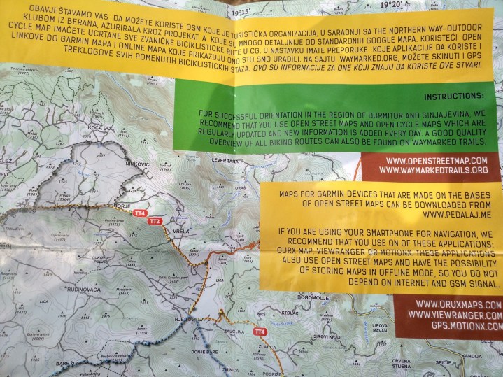
The tourism department of the Durmitor National Park in Zabljak, (Montenegro) recommends using OSM 1 | Photo CC0
Mapping
- "Stumbling blocks" (German Stolpersteine) - these are small copper tablets that are installed in those places (throughout Europe) where a person was taken to a concentration camp or killed by the Nazis. The user of Reclus asked (automatic translation ): are all 8.7 thousand "stumbling blocks" that are in the Wikidata project related to OpenStreetMap.
- User Hauke Stieler made (automatic translation ) a map of objects tagged with
shop=yes in Germany. In version v4.22.0, OpenStreetMap Carto shop=yes no longer rendered. - Voting has begun on a tagging scheme developed by amilopowers, by which it will be possible to mark the possibility of withdrawing cash at a store or other location.
- Klumbumbus user suggests introducing a new tag
traffic_calming=dynamic_bump , which can be used to mark a new type of special road devices that can calm traffic depending on speed. He is waiting for our opinion. - Vadim Shlyakhov suggests
leisure=sunbathing places where people can sunbathe outdoors.
Community
- The OSM operating team reported that it would soon be impossible to anonymously comment on notes. The reason for this decision and additional background information is on GitHub , where this issue was raised two years ago.
- Samuel Darkwah Manu, founder of the Kwame Nkrumah University of Science and Technology YouthMappers team and member of the OSM community in Ghana, shares his experiences with the Open Cities Accra project.
- We ask everyone Take part in voting for candidates for the OpenStreetMap Awards 2019 . Voting will end on September 18, so do it right now.
OpenStreetMap Foundation
- Kate Chapman said that this year Mikel Maron plans to be re-elected in the upcoming OSMF Council, and Frederick Ramm and Kate Chapman will resign.
Developments
- The opening date of the State of the Map conference, which this year will be held in the German city of Heidelberg from September 21 to 23, is drawing near. This is one of the main events in the OSM world. Exactly in the same place, but a little earlier, the HOT summit will be held.
- Lucas and Fabian from HeiGIT at the FOSS4G 2019 Conference in Bucharest
conducted a 1.5 hour workshop on analyzing OpenStreetMap data history on the ohsome platform. Training materials and code are presented as interconnected fragments in GIScience HD Gitlab .
Humanitarian OSM
- HOT talks about how they tried to make an effective MSW collection system using an open source application in a city in Dar es Salaam (Tanzania).
Cards
- [1] The tourism department of the Durmitor National Park in Zabljak (Montenegro) posted a recommendation on its maps for bike rides - use OSM. They also posted the following information on their official website : “For successful orientation in Durmitor and Sinyayevin, we recommend using OpenStreetMap and Open Cycle Maps, which are regularly updated.”
Open data
- The federal state of Saxony (Germany) has opened (automatic translation ) access to aerial photographs, digital topographic maps, terrain and landscape models, as well as cadastral data. Unfortunately, all this is laid out under a license similar to CC-BY, and therefore cannot freely "migrate" to OSM. However, orthophotos, a general map and road names, building boundaries and their numbers were and will continue to be available to OSM cartographers.
- A video from the FOSS4G Bucharest conference on how to use OSM and Wikidata along with tools for learning data and Python has been uploaded to the CCC website.
Programming
- The tchaddad user in his diary talks about how Wikidata queries work using SPARQL and the API, and also explains how the Wikidata project can help make Nominatim better.
Releases
- Paul Norman announced an update to the main OSM map style, Carto. Bugs were fixed, the code was “cleaned” to increase productivity, and the display of shopping centers on the map was changed. In addition,
historic=citywalls rendered in exactly the same way as barrier=city_wall . - Sarah Hoffmann announced the release of a new version of osm2pgsql - 1.0.0. In addition to significant functional improvements, old-style multipolygons are also no longer supported.
Did you know …
- ... ... that Matt Mickus found the answer to the question: is the coastline in Minnesota longer than in California, Hawaii and Florida combined or not? Using OSM data, he concluded that yes - more if you include more rivers and streams.
- ....... about the Copenhill ski resort, which is located in the Danish capital Copenhagen? This unique project was built on the green roof of the incinerator so that the Danes could spend their holidays and ride without leaving. In OSM, it looks like this .
OSM in the media
- The Austrian newspaper Der Standard published an article
 about card distortion in China. Russia stopped such a practice in the late 80s of the last century, although it also previously “shifted” roads, rivers, and city blocks. Despite the availability of publicly accessible satellite images, China for some reason continues this strange tradition. 68-point Chinese Map Law requires only approved maps with “correct” borders to be published. By the way, in China, only 14 companies are licensed to produce and publish cards. It is assumed that the "offset" on Chinese maps is from 50 to 700 meters and can be seen if you compare the satellite image from Google and the map itself. The OSM article is mentioned as an alternative to dubious legal requirements.
Other geo events
- On the third day of the Pista ng Mapa conference, Lee launched her DJI Phantom 4 quadrocopter into the sky to see the venue and its surroundings. After the flight, Lee uploaded all the data she received to OpenAerialMap, including altitude models. User Maning Sembail shows how to use QGIS to extract heights from DSM / DTM sources and use this information to build polygons in OpenStreetMap.
- This year, the African Conference on Geospatial Data and the Internet will be held in Accra, October 22-24, in the capital of Ghana. The purpose of the conference is to gather stakeholders to discuss public policy issues in the areas of geospatial and open data, ICT and the Internet.
- For almost 30 years, the WGS84 geodetic coordinate system has been the base and allows you to convert data from one system to another. Michael Dzhudichi says that in a world requiring submeter accuracy, the use of WGS84 is becoming irrelevant. Currently, the “ GDAL coordinate system ” is working on improving GDAL, PROJ, and libgeotiff so that they can process time-dependent coordinate systems and accurately convert data from one system to another.
- Katya Seidel has studied (automatic translation ) alternatives to the GPSies service, which was recently announced with AllTrails .
Communication of Russian OpenStreetMap participants is in the Telegram chat room and on the forum . There are also groups on social networks VKontakte , Facebook , but they mainly publish news.
Join OSM!
Previous issues: 475 , 474 , 473 , 472 , 471
Source: https://habr.com/ru/post/467499/
All Articles